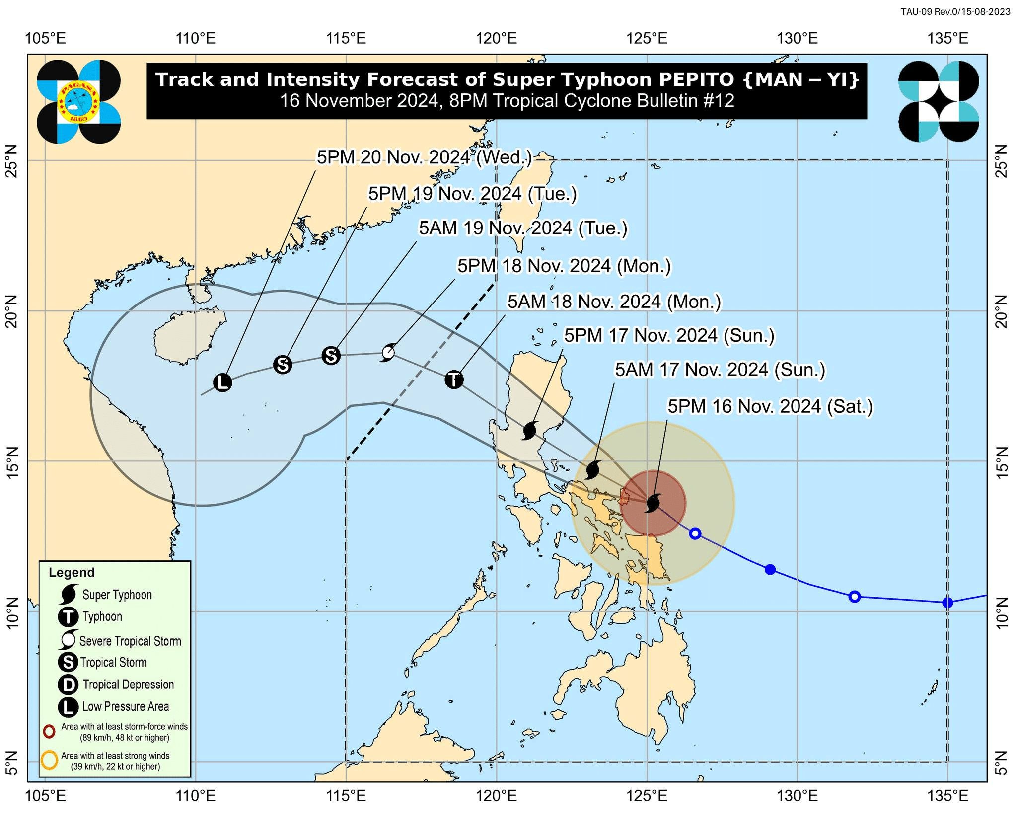

Track and intensity forecast of Super Typhoon Pepito (international name: Man-yi) as of 8 p.m. on Saturday, November 16, 2024. Image from Pagasa Facebook
MANILA, Philippines — Super Typhoon Pepito (international name: Man-yi) is about to make a landfall along the eastern coast of Catanduanes on Saturday evening, the Philippine Atmospheric, Geophysical and Astronomical Services Administration (Pagasa) said.
READ: LIVE UPDATES: Typhoon Pepito
Article continues after this advertisementIn its 8 p.m. weather bulletin, Pagasa said that the center of the eye of Pepito was last located over the coastal waters of Gigmoto, Catanduanes, moving northwestward at 20 kilometers per hour (kph).
FEATURED STORIES NEWSINFO Super Typhoon Pepito now approaching landfall in Catanduanes NEWSINFO LIST: Areas at high risk of storm surge due to Super Typhoon Pepito NEWSINFO Pepito makes landfall in CatanduanesIt was still packing a maximum wind speed of 195 kph and gustiness of up to 240 kph.
READ: Pepito to make landfall in Catanduanes within next few hours
Article continues after this advertisementPagasa said Pepito “is forecast to move generally west northwestward and make landfall over the northern or central portion of Catanduanes between 8:00 P.M. and 10:00 P.M. tonight.”
Article continues after this advertisementPagasa added that “it is possible, although becoming less likely, that Pepito will just pass very close to Catanduanes (but bring the southern eyewall and its violent conditions over most of Catanduanes).”
Article continues after this advertisementFurther, Pepito is expected to pass over the waters north of Camarines Province (until early Sunday morning) and Polillo Islands (between Sunday morning and noon) before making landfall over northern Quezon or central or southern Aurora between Sunday noon or afternoon.
The super typhoon will then cross the northern portion of Central Luzon and the southern portion of Northern Luzon along the upland areas of Sierra Madre, Caraballo, Cordillera Central between Sunday afternoon and evening.
Article continues after this advertisementPagasa also warned that areas outside the landfall point and forecast confidence cone may experience hazards such as heavy rainfall, severe winds, and storm surge.
The weather agency hoisted Tropical Cyclone Wind Signals (TCWS) across the country, with TCWS No. 5 being the highest over Catanduanes and the northeastern portion of Camarines Sur. This may bring extreme threat to life and property, with wind speed ranging from 185 kph or higher.
A storm surge warning, where peak heights exceeding 3.0 meters, is expected in the next 48 hours over low-lying or exposed coastal communities of the following areas:
Ilocos Region (western coast) Isabela Central Luzon Metro Manila Calabarzon (Cavite, Laguna, Batangas, Rizal, Quezon) Marinduque Bicol Region Northern Samar Samar Eastern Samar Biliran

Storm surge warning graphic from DOST / Pagasa
READ: Pepito’s strength reaching peak intensity, possible catastrophic level
Subscribe to our daily newsletter
Meanwhilesbet, a gale warning was hoisted over the eastern and southern seaboards of Southern Luzon and the eastern seaboard of Visayas.
READ NEXT Legazpi City orders curfew amid threat of Pepito Satellite connections established in CamSur amid threat of Pepito EDITORS' PICK Camarines Sur areas now under Signal No. 5 due to Pepito LIVE: PVL All-Filipino Conference November 16 Legarda hails enactment of Bacoor Assembly of 1898 Act Alden Richards nanliligaw na nga ba kay Kathryn Bernardo? Jake Paul beats 58-year-old Mike Tyson as hits don’t match hype This immersive K-pop exhibit is coming to the Philippines MOST READ 67 Eastern Visayas 2025 poll candidates are unopposed Miss Universe 2024 Live Updates LIVE UPDATES: Super Typhoon Pepito Super Typhoon Pepito now approaching landfall in Catanduanes Follow @FMangosingINQ on Twitter --> View comments